
Ecoregion Download Files by State - Region 1
Notice
If you are having issues downloading the files on EcoRegions website, we recommend you try opening the site in another web browser. Or copy the link address to another tab to open the attachment in a new window.
Select a state for descriptive information about that state's Level III and IV ecoregions. Additionally, each state section contains links to downloadable maps in PDF format, and files containing GIS datasets (shapefiles, metadata, and symbology data).
Some Web content for Level IV Ecoregions is under construction. If you do not find a link to a state that has been completed, maps and GIS data are available on the Ecoregion FTP site and web content will be available shortly.
NOTE: maps and GIS files may differ. To make sure you are using the most current ecoregion data, download shapefiles of ecoregions.
New England
GIS Data (shapefiles, metadata and symbology)
Instructions for applying symbology to ecoregions
New England -- EPA Region 1
- Region 1 Level III Shapefile (1.58 mb)
- Region 1 Level III Metadata and Region 1 Level III Symbology
- Region 1 Level IV Shapefile (1.45 mb)
- Region 1 Level IV Metadata and Region 1 Level IV Symbology
Massachusetts
- Massachusetts Level III Shapefile (1.58 mb)
- Massachusetts Level III Metadata and Massachusetts Level III Symbology
- Massachusetts Level IV Shapefile (1.45 mb)
- Massachusetts Level IV Metadata and Massachusetts Level IV Symbology
Connecticut
- Connecticut Level III Shapefile (376 kb)
- Connecticut Level III Metadata and Connecticut Level III Symbology
- Connecticut Level IV Shapefile (376 kb)
- Connecticut Level IV Metadata and Connecticut Level IV Symbology
Rhode Island
- Rhode Island Level III Shapefile (314 kb)
- Rhode Island Level III Metadata and Rhode Island Level III Symbology
- Rhode Island Level IV Shapefile (287 kb)
- Rhode Island Level IV Metadata and Rhode Island Level IV Symbology
New Hampshire
- New Hampshire Level III Shapefile (219 kb)
- New Hampshire Level III Metadata and New Hampshire Level III Symbology
- New Hampshire Level IV Shapefile (319 kb)
- New Hampshire Level IV Metadata and New Hampshire Level IV Symbology
Vermont
- Vermont Level III Shapefile (95 kb)
- Vermont Level III Metadata and Vermont Level III Symbology
- Vermont Level IV Shapefile (191 kb)
- Vermont Level IV Metadata and Vermont Level IV Symbology
Maine
- Maine Level III Shapefile (1.46 mb)
- Maine Level III Metadata and Maine Level III Symbology
- Maine Level IV Shapefile (1.48 mb)
- Maine Level IV Metadata and Maine Level IV Symbology
Maps (available in PDF format)
- Level IV Ecoregions of New England-- poster front side 48" X 36" (38 mb)
- Level IV Ecoregions of New England--poster back side 46" X 36" (322 kb)
- Level IV Ecoregions of New England-- 19" X 25" (1.98 mb)
- Level IV Ecoregions of New England-- page size (1.88 mb)
- Level IV Ecoregions of New England--19" X 25" (16 mb)
| Thumbnails for New England Maps | |
|---|---|
|
|
|
|
|
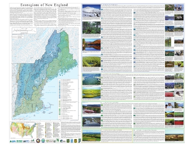
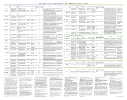
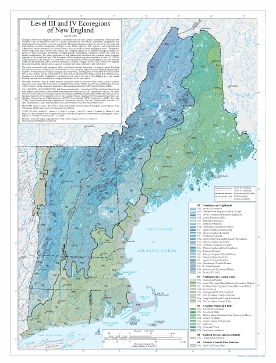
Ecoregions denote areas of general similarity in ecosystems and in the type, quality, and quantity of environmental resources; they are designed to serve as a spatial framework for the research, assessment, management, and monitoring of ecosystems and ecosystem components. By recognizing the spatial differences in the capacities and potentials of ecosystems, ecoregions stratify the environment by its probable response to disturbance (Bryce and others, 1999). These general purpose regions are critical for structuring and implementing ecosystem management strategies across federal agencies, state agencies, and nongovernment organizations that are responsible for different types of resources within the same geographical areas (Omernik and others, 2000).
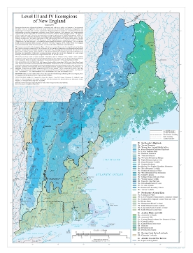
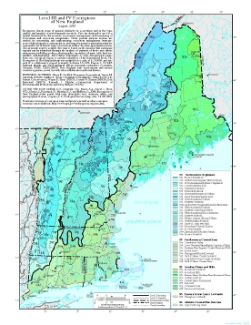
The New England ecoregion map was compiled at a scale of 1:250,000. It revises and subdivides an earlier national ecoregion map that was originally compiled at a smaller scale (USEPA, 2009; Omernik, 1987). The approach used to compile this map is based on the premise that ecological regions can be identified through the analysis of the spatial patterns and the composition of biotic and abiotic phenomena that affect or reflect differences in ecosystem quality and integrity (Wiken, 1986; Omernik, 1987, 1995). These phenomena include geology, physiography, vegetation, climate, soils, land use, wildlife, and hydrology. The relative importance of each characteristic varies from one ecological region to another regardless of the hierarchical level.
A Roman numeral hierarchical scheme has been adopted for different levels of ecological regions. Level I is the coarsest level, dividing North America into 15 ecological regions. Level II divides the continent into 50 regions (Commission for Environmental Cooperation Working Group, 1997). At level III, the continental United States contains 104 ecoregions and the conterminous United States has 84 ecoregions (United States Environmental Protection Agency [USEPA], 2009). Level IV is a further subdivision of level III ecoregions. Explanations of the methods used to define the USEPA’s ecoregions are given in Omernik (1995, 2004), Omernik and others (2000), and Gallant and others (1989).
New England contains low coastal plains, rocky coasts, river floodplains, alluvial valleys, glacial lakes, forested mountains, and alpine peaks. Ecological diversity is great. There are 5 level III ecoregions and 40 level IV ecoregions in the New England states and many continue into ecologically similar parts of adjacent states or provinces.
This poster is part of a collaborative project primarily between USEPA Region I, USEPA National Health and Environmental Effects Research Laboratory (Corvallis, Oregon), U.S. Department of Agriculture (USDA)–Natural Resources Conservation Service (NRCS), U.S. Geological Survey (USGS)–Earth Resources Observation and Science (EROS) Center, and several state agencies of Maine, New Hampshire, Vermont, Massachusetts, Connecticut, and Rhode Island. The project is associated with an interagency effort to develop a common framework of ecological regions (McMahon and others, 2001). Reaching that objective requires recognition of the differences in the conceptual approaches and mapping methodologies applied to develop the most common ecoregion-type frameworks, including those developed by the USDA–Forest Service (Bailey and others, 1994, Cleland and others 2007), the USEPA (Omernik, 1987, 1995), and the NRCS (U.S. Department of Agriculture–Soil Conservation Service, 1981, U.S. Department of Agriculture–Natural Resources Conservation Service, 2006). As each of these frameworks is further refined, their differences are becoming less discernible. Collaborative ecoregion projects, such as this one in New England, are a step toward attaining consensus and consistency in ecoregion frameworks for the entire nation.
Literature Cited:
Bailey, R.G., Avers, P.E., King, T., and McNab, W.H., eds., 1994, Ecoregions and subregions of the United States (map) (supplementary table of map unit descriptions compiled and edited by McNab, W.H. and Bailey, R.G.): Washington, D.C., U.S. Department of Agriculture–Forest Service, scale 1:7,500,000.
Bryce, S.A., Omernik, J.M., and Larsen, D.P., 1999, Ecoregions – a geographic framework to guide risk characterization and ecosystem management: Environmental Practice, v. 1, no. 3, p. 141-155.
Cleland, D.T., Freeouf, J.A., Keys, J.E., Jr., Nowacki, G.J., Carpenter, C., and McNab, W.H., 2007, Ecological subregions – sections and subsections of the conterminous United States: Washington, D.C., U.S. Department of Agriculture–Forest Service, General Technical Report WO-76, scale 1:3,500,000.
Commission for Environmental Cooperation Working Group, 1997, Ecological regions of North America – toward a common perspective: Montreal, Commission for Environmental Cooperation, 71 p.
Gallant, A.L., Whittier, T.R., Larsen, D.P., Omernik, J.M., and Hughes, R.M., 1989, Regionalization as a tool for managing environmental resources: Corvallis, Oregon, U.S. Environmental Protection Agency, EPA/600/3-89/060, 152 p.
McMahon, G., Gregonis, S.M., Waltman, S.W., Omernik, J.M., Thorson, T.D., Freeouf, J.A., Rorick, A.H., and Keys, J.E., 2001, Developing a spatial framework of common ecological regions for the conterminous United States: Environmental Management, v. 28, no. 3, p. 293-316.
Omernik, J.M., 1987, Ecoregions of the conterminous United States (map supplement): Annals of the Association of American Geographers, v. 77, no. 1, p. 118-125, scale 1:7,500,000.
Omernik, J.M., 1995, Ecoregions – a framework for environmental management, in Davis, W.S. and Simon, T.P., eds., Biological assessment and criteria-tools for water resource planning and decision making: Boca Raton, Florida, Lewis Publishers, p. 49-62.
Omernik, J.M., 2004, Perspectives on the nature and definition of ecological regions: Environmental Management, v. 34, Supplement 1, p. s27-s38.
Omernik, J.M., Chapman, S.S., Lillie, R.A., and Dumke, R.T., 2000, Ecoregions of Wisconsin: Transactions of the Wisconsin Academy of Sciences, Arts, and Letters, v. 88, p. 77-103.
U.S. Department of Agriculture–Natural Resources Conservation Service, 2006, Land resource regions and major land resource areas of the United States, the Caribbean, and the Pacific Basin: Washington, D.C., U.S. Government Printing Office, Agriculture Handbook 296, 669 p. + map./p>
U.S. Department of Agriculture–Soil Conservation Service, 1981, Land resource regions and major land resource areas of the United States: Agriculture Handbook 296, 156 p.
U.S. Environmental Protection Agency, 2009, Level III ecoregions of the continental United States (revision of Omernik, 1987): Corvallis, Oregon, USEPA – National Health and Environmental Effects Research Laboratory, Map M-1, various scales.
Wiken, E., 1986, Terrestrial ecozones of Canada: Ottawa, Environment Canada, Ecological Land Classification Series no. 19, 26 p.
PRINCIPAL AUTHORS: Glenn E. Griffith (Dynamac Corporation), James M. Omernik (USGS), Sandra A. Bryce (Dynamac Corporation), Joshua Royte (The Nature Conservancy [TNC]), Wayne D. Hoar (NRCS), Joseph W. Homer (NRCS), Don Keirstead (NRCS), Kenneth J. Metzler (Connecticut Department of Environmental Protection [CT DEP]), and Greg Hellyer (USEPA).
COLLABORATORS AND CONTRIBUTORS: Beth Timmons (Raytheon/SRA), Katrina Kipp (USEPA), Andy Cutko (Maine Natural Areas Program), Dave Halliwell (Maine Department of Environmental Protection [ME DEP]), Roy Bouchard (ME DEP), Sue Gawler (NatureServe), Steve Fuller (New Hampshire Fish and Game Department [NHFG]), Emily Brunkhurst (NHFG), Rick Chormann (New Hampshire Department of Environmental Services), Rich Langdon (Vermont Department of Environmental Conservation), Leif Richardson (Vermont Fish and Wildlife Department [VTFW]), Everett Marshall (VTFW), Caroline Alves (NRCS), Tom Faber (USEPA), Robert Haynes (Massachusetts Department of Environmental Protection), Tad Larsen (Raytheon/SRA), Lisa Wahle (CT DEP), Guy Hoffman (CT DEP), John Hutchinson (USGS), Jack Wittmann (USGS), and Tom Loveland (USGS).
REVIEWERS: Charles E. Ferree (TNC), Patricia Swain (Massachusetts Natural Heritage and Endangered Species Program), Bruce W. Thompson (NRCS-retired), and Peter D. Vaux (University of Maine).
CITING THIS POSTER: Griffith, G.E., Omernik, J.M., Bryce, S.A., Royte, J., Hoar, W.D., Homer, J.W., Keirstead, D., Metzler, K.J., and Hellyer, G., 2009, Ecoregions of New England (color poster with map, descriptive text, summary tables, and photographs): Reston, Virginia, U.S. Geological Survey (map scale 1:1,325,000).
This project was partially supported by funds from the Environmental Protection Agency's Office of Research and Development, Regional Applied Research Effort (RARE) program.