
EPA Geospatial Metadata Style Guide using EME 5 and EME for Pro
Introduction
This Style Guide provides recommendations and instructions for using EPA Metadata Editor to create geospatial metadata conforming to EPA’s Metadata Technical Specification, ISO’s 19115 standard endorsed by the Federal Geographic Data Committee (FGDC), and OMB’s Project Open Data (POD) schema. EME v5.0 is EPA’s customization of Esri’s metadata editors found in ArcCatalog and ArcGIS Pro and creates ISO/POD-compliant ArcGIS Metadata. For more information about downloading and installing the EME v5.0 toolkit for ArcCatalog, go to the EME v5.0 GitHub site and for ArcGIS Pro, go to the EME for Pro GitHub site.
This guide does not detail the process to publish metadata records to the Enterprise Data Catalog (EDC). Please consult documents at the EDC Home page for help on publishing metadata to EDG. For additional assistance, please contact the EDG Team (edc@epa.gov).
For additional metadata style guides, please refer to the EPA Metadata Style Guide for Geospatial and Non Geospatial Data page.
How this Style Guide is Organized
For convenience, this Style Guide has been organized to include a “Quick Navigation” section which lists (in table form) each of the Core EPA Metadata Fields from EPA’s Metadata Technical Specification. You may use this table to quickly navigate to guidance for each field. Or, you may follow along in the guide to gather additional information about EME v5.0’s basic functionality.
Quick Navigation - Core EPA Metadata Fields
| Field Name | Description | Required? | Geospatial Only? |
|---|---|---|---|
| Title | Human-readable name of the asset. Should be in plain English and include sufficient detail to facilitate search and discovery. | Always | All |
| Description | Human-readable description (e.g., an abstract) with sufficient detail to enable a user to quickly understand whether the asset is of interest. | Always | All |
| Tags (General) | Tags (or keywords) help users discover your dataset; EPA requires the use of keywords from several different standard thesauruses; please also include terms that would be used by technical and non-technical users. | Always | All |
| Tags (ISO) | The ISO 19115 Topic Category is a general categorization of data resources that is intended to provide data classification consistency across agencies. | Always | All |
| Tags (Place) | One or more geographic feature names describing the range of spatial applicability of the dataset. | Always | All |
| Tags (EPA Org) | The organization within the EPA responsible for the stewardship of this dataset. If this dataset is produced and maintained by an external agency, this field should be set to non-EPA. | Pending | All |
| Tags (EPA Theme) | Thematic keywords commonly used to describe EPA datasets, recommended to promote consistency across the agency. | Optional | All |
| Tags (Federal Program Code) | Federal program inventory code corresponding to the program responsible for the production and maintenance of this dataset. | Always | All |
| Last Update | Most recent date on which the dataset was changed, updated or modified, or for continually updated data, the frequency with which the data are updated. | Always | All |
| Publishing Organization | The title of the organization responsible for publishing the dataset | Always | All |
| Publisher | The name of a contact responsible for the dataset | Always | All |
| Publisher Email | The email address where questions about this dataset should be sent. | Always | All |
| Identifier | This element is a unique identifier for the metadata record. It may be a UUID or DOI. | Always | All |
| Access Level | The degree to which this dataset could be made publicly-available, regardless of whether it has been made available. Choices: public (Data asset is or could be made publicly available to all without restrictions), restricted public (Data asset is available under certain use restrictions), or non-public (Data asset is not available to members of the public). | Always | All |
| Rights | An explanation for the selected “accessLevel” including instructions for how to access a restricted file, if applicable, or explanation for why a “non-public” or “restricted public” data asset is not “public,” if applicable. Text, 255 characters. | Required if Access Level is not public | All |
| Data License | The URL to a web page describing the data license governing the use of this dataset. | Always | All |
| System of Records | If the system is designated as a system of records under the Privacy Act of 1974, provide the URL to the System of Records Notice related to this dataset. | Required if metadata represents a system of record | All |
| General Use Limitation | This optional field allows any general use limitations to be included. | Optional | Geo Only |
| Spatial Extent | The range of spatial applicability of a dataset. Should include a spatial region like a bounding box but may also be a named place. | Required for geospatial data | All |
| Temporal Extent | The range of temporal applicability of a dataset (i.e., a start and end date of applicability for the data). | Always | All |
| Distribution URL | One or more URLs providing access to the dataset | Mandatory if Applicable | All |
| Metadata Date Stamp | The date when the metadata was created or last updated | Always | Geo Only |
| Update Frequency | The frequency with which dataset is published or updated. | Mandatory for Geo | All |
| Metadata Responsible Party | Contact information for the party responsible for creating and maintaining the metadata. | Always | Geo Only |
| Language | The language of the metadata document | Required for geospatial data | All |
| Country | The country in which the metadata document was produced. | Required for geospatial data | Geo Only |
| Spatial Reference | Identification of the horizontal projections, vertical datums and temporal reference systems used. | Required for geospatial data | Geo Only |
| Spatial Data Representation | Digital representation of spatial information in the dataset. (Vector/Grid, Point/Line/Polygon etc.) | Required for geospatial data | Geo Only |
Prepare Geospatial Metadata Using EME v5.0 in Esri ArcCatalog or EME for Pro in ArcGIS Pro
To prepare geospatial metadata using EME v5, you must install the EME v5.0 toolkit.
For more information about downloading and installing the toolkit for ArcCatalog, go to the EME v5.0 GitHub site.
For more information about downloading and installing the ArcGIS Pro add-in tool, go to the EME for Pro GitHub site.
Instructions for using this guide
This guide conforms to the EPA Metadata Technical Specification which provides a list of core EPA metadata fields. Most fields in the Technical Specification list are required for EPA metadata while some are optional. Additional optional fields that are not listed in the Technical Specification are included in this guide due to their importance in geospatial metadata. You are encouraged to complete optional metadata fields to provide data users with as much information about the dataset as possible.
This guide steps through the EME pages that contain required and optional fields to complete. For each field, instructions, suggestions for appropriate field entries, and a link to the field’s section in the EPA Metadata Technical Specification (where applicable) are provided. Many fields are designed with pre-populated values that may be selected from a dropdown menu while others are free text.
For assistance with locating suggested EPA organization names used to complete metadata fields, please refer to EPA’s Metadata Style Guide – Keywords and EPA Organization Names. Top of Page
How to complete required metadata fields
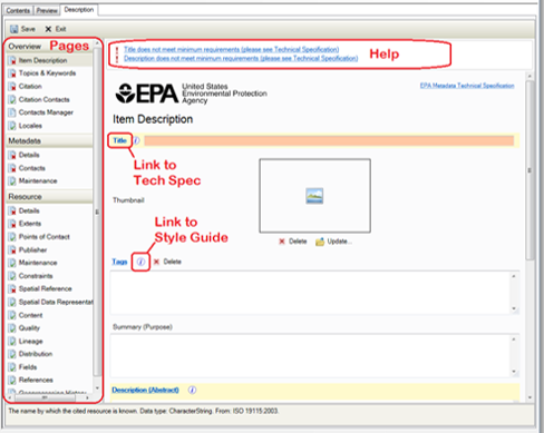
EME is organized within ArcCatalog as a table of contents. By clicking on a page, a set of metadata fields displays in the editing pane. Pages symbolized with a red X are accompanied by text at the top of the window indicating the fields in the selected page that do not meet minimum metadata requirements. Invalid text fields needing correction are shaded in pink or peach within the editing pane (dropdown and date fields do not support this coloring). On many pages the invalid field is immediately visible within the editing pane. On some pages, however, the invalid field may be hidden in an expandable section.
Mandatory fields are shaded in light yellow, but be aware that because of the expandable sections it is possible that mandatory elements may not be visible at first glance. Most mandatory fields have a direct link to their reference in the EPA Metadata Technical Specification (signified by the blue hyperlink field name). In addition, most mandatory fields also have a direct link to their entry in this Style Guide (signified by circled “i” symbol).
Complete the fields in each EME table of contents page as described in the following sections to create ISO/POD-compliant ArcGIS metadata that is descriptive and complete.Top of Page
Overview – Item Description page
Title [required]
Guidance: Titles should be succinct yet descriptive including the topic, and where relevant, temporal info, geography and related programs in a way that distinguishes it from other, similar resources/
Suggested Text: {Subject, Geographic Extent, Relevant Time Period, Data Owner/Provider, Office/Region/Research Lab of Data Owner}
Examples:
- Toxics Release Inventory (TRI) Locations, Oklahoma, 2012, EPA OEI, EPA REG 06 WQPD
- Tribal Lands, Idaho, 2000, Bureau of Indian Affairs, EPA REG 10
- Potomac River Basin Boundary, Chesapeake Bay Program
Metadata Technical Specification: Title
Tags [special instructions MUST be followed]
Special instructions: Tags are required in EPA metadata. However, EME has disabled editing on this field as tags should NOT be added here. Instead, tags should be added in the “Topics and Keywords” page. See instructions for each of the individual topic/keyword sections in this Style Guide to add tags by type:
- ISO 19115 Topic Categories
- Place Keywords
- EPA Keywords
- Program Code Keywords
- EPA Organization (pending addition in future EME release)
If any tags exist in this field (i.e. from a previous version of the metadata) follow this process:
- Determine if you want to keep any of the existing tags.
- To keep tags, they must be added to your local EME database in User Keywords.
- Once you have duplicated the desired tags from the Tags field to your User Keywords section, or if you determine that you do not want any existing tags, the tags must be removed from the Tags field by clicking “Delete.”
NOTE: leaving any text in the Tags field renders the metadata invalid.
Guidance: Follow the special instructions above. If tags exist in this field they must be deleted or the metadata will be invalid.
Metadata Technical Specification: Tags (General)
Summary (Purpose) [optional, but recommended]
Guidance: Distill the Description (Abstract) below into a one-sentence summary.
Suggested Text: This geospatial dataset provides {describe the dataset layer or layers' general content and features and how they may be used}.
Examples:
- This raster GIS dataset contains salinity measurements in the Chesapeake Bay and its tidal tributaries during Fall season.
- This geospatial datset contains layers that depict National Register of Historic Places locations in the US.
Description (Abstract) [required]
Guidance: Descriptions should be used to provide a brief summary of the resource.
Suggested Text: This geospatial dataset contains {describe the dataset layer or layers' general content and features, geographic coverage, time period of content, and any special data characteristics or limitations}.
Examples:
- This raster GIS dataset contains 100-meter-resolution cells depicting mean surface salinity (parts per thousand) in the Chesapeake Bay and its tidal tributaries during Fall season. Salinity was measured annually from 1985 to 2006.
- This geospatial dataset contains point and polygon layers that depict National Register of Historic Places locations in the US compiled by the National Park Service in 2015. Layers include cultural resource sites, buildings, districts, objects, and structures.
Metadata Technical Specification: Description
Bounding Box [required]
Guidance: The bounding box is the spatial extent of the dataset, represented as north, south, east, and west geographic coordinates in decimal degrees referenced to the WGS84 datum. The bounding box fields will auto-populate when synchronizing to a dataset.
Metadata Technical Specification: Spatial Extent
Overview – Topics & Keywords page
Four keywords sections are required to meet metadata compliance. They are as follows:
ISO 19115 Topic Categories [required]
Guidance: Select one or more ISO 19115 topic categories from the checklist that correspond to the dataset being described.
Metadata Technical Specification: Tags (ISO)
EPA Keywords [optional, but recommended]
Guidance: Select one or more place keywords from the checklist that correspond to the dataset being described.
Metadata Technical Specification: Tags (EPA Theme)
Program Code Keywords [required]
Guidance: Select one or more program code keywords from the checklist that correspond to the program making the dataset available.
Metadata Technical Specification: Tags (Federal Program Code)
Place Keywords [required]
Guidance: Select one or more place keywords from the checklist that correspond to the dataset being described.
Metadata Technical Specification: Tags (Place)
EPA Organization [pending]
Guidance: This functionality will be added in a future version of EME.
Metadata Technical Specification: Tags (EPA Org)
User Keywords [optional]
Guidance: Select one or more user keywords from the checklist. User keywords are keywords you create and store in your local EME database. The list may be edited in the EME Database Manager.
Overview – Citation page
The Citation page contains many fields that provide information about the dataset being described. Most fields are optional. The Dates field is a required entry.
Dates [required]
Guidance: Enter the date when the geospatial data resource was Published, Created, or Revised, whichever is most applicable. Use the calendar to select the date. Navigate the calendar month-by-month by clicking the back or forward arrows, or click on the month text or year text between the arrows to quickly navigate through several months or years.
Metadata Technical Specification: Last Update
Metadata – Details page
File Identifier [required]
Guidance: The file identifier is the unique identifier for the metadata record. This identifier may be a UUID string or a DOI URL. If this metadata record is replacing one that already exists, you may re-use the existing identifier by typing it into the field, or you may generate a new one by clicking Create.
Example UUID: 8B7D82BE-B130-44B8-99FB-192973508BE8
Metadata Technical Specification: Identifier
Date Stamp [required]
Guidance: The date stamp is the date the metadata record was last edited. EME will update the date stamp automatically when any edits are made to the metadata.
Metadata Technical Specification: Metadata Date Stamp
Language [required]
Guidance: Use the dropdown list to select the language used in the metadata text. For convenience, the default is set to English. This may be changed if the language is other than English.
Metadata Technical Specification: Language
Country [required]
Guidance: Use the dropdown list to select the country the metadata was created in. For convenience, the default is set to United States. This may be changed if the country is other than United States.
Metadata Technical Specification: Country
Metadata – Contacts page
Load a contact [required]
Guidance: This section of EME allows you to add contact information for the individual responsible for the metadata record. You may choose to Load a contact from the dropdown list or create a New Contact with the metadata point-of-contact’s information if your desired contact name does not appear in the dropdown list.
Metadata Technical Specification: Metadata Responsible Party
Selecting a contact from the “Load a contact” dropdown
When you load a contact, select the name of the metadata contact from the dropdown list and click Load.
The contact information is loaded into the metadata record. You may then view all fields related to the contact by clicking each down arrow to open all of the expandable sections in the contacts view:
Clicking each down arrow provides access to the full set of contact fields. Review all fields for the contact selected from the dropdown list to ensure that required fields are complete. Note: EPA follows NOAA guidance which states that the Metadata Contact Role field should always be set to “Point of Contact.” This is set automatically for EPA Directory contacts.
Adding a contact manually
If your desired contact name does not appear in the Load a contact dropdown list, you may create a new contact. Click New Contact:
A set of contact fields comes into view. Add the new contact information to these fields.
Name [required]
Guidance: Review, edit, or add the full name of the person responsible for publishing the metadata. This may also be a helpdesk team name when appropriate.
Example: Jane Doe
Organization [required]
Guidance: Review, edit, or add the full standardized name of the EPA organization responsible for publishing the metadata. For datasets that originate within EPA, the name must always begin with “U.S. EPA” or “U.S. Environmental Protection Agency.”
Example: U.S. EPA Office of Environmental Information (OEI)
Position [required]
Guidance: Review, edit, or add the position of the individual listed in the Name field.
Example: Geospatial Data Steward
Role [required]
Guidance: Use the dropdown list to select the role of the individual listed in the Name field. EPA follows NOAA guidance which states that this Role field should always be set to “Point of Contact.”
Example: Point of Contact
Email [optional, but recommended]
Guidance: Review, edit, or add the email address of the individual listed in the Name field. A helpdesk email address may be used if appropriate.
Example: doe.jane@agency.gov
Linkage [required]
Guidance: Review, edit, or add an online linkage to a website describing the program or project associated with the individual listed in the Name field. This linkage field is NOT for access to the dataset.
Example: https://www.epa.gov/aboutepa/epa-region-9-pacific-southwest
Protocol [required]
Guidance: Use the dropdown list to describe the type of linkage listed in the field immediately above.
Example: Web Address (URL)
Resource – Extents page
Temporal Period Extent [required]
Guidance: A temporal extent must be added to the metadata that describes the time period that the data represents (for example, a period of data collection). Add a temporal extent by clicking New Extent.
Metadata Technical Specification: Temporal Extent
Click New Temporal Period Extent.
Use the calendar interface to add the “Begin Date/Time” and/or “End Date/Time.” At least one date must be added for compliance. Navigate the calendar month-by-month by clicking the back or forward arrows, or click on the month text or year text between the arrows to quickly navigate through several months or years.
Resource – Points of Contact page
Guidance: This section of EME allows you to add contact information for the individual responsible for the publication of the dataset. You may choose to Load a contact from the dropdown list or complete the “Contact:" fields with the dataset publisher’s information if your desired contact name does not appear in the dropdown list.
Special note about the importance of the Contact (Publisher) “Organization” field: “Organization” is the principal field that identifies EPA metadata and differentiates EPA from non-EPA metadata. EPA metadata is contributed to Data.gov when “Organization” text starts with the following:
- U.S. EPA
- U.S. Environmental Protection Agency
If EPA is not the publishing entity, this element may be free text, containing the name of the publishing entity, and the metadata record will not be contributed to Data.gov as an EPA record.
Adding a contact from the “Load a contact” dropdown
When you load a contact, select the name of the metadata contact from the dropdown list and click Load. All contacts in the dropdown list contain the proper “Organization” nomenclature to ensure that the metadata record is identified as originating with EPA, and is intended to be contributed to Data.gov.
The contact information is loaded into the metadata record. You may then view all fields related to the contact by clicking each down arrow in the contacts view:
Clicking each down arrow provides access to the full set of contact fields. Review all fields for the contact selected from the dropdown list to ensure that required fields are complete. Note: EPA requires the Resource Point of Contact Role field be set to “Publisher.” This is set automatically for EPA Directory contacts.
Adding a contact manually
If your desired contact name does not appear in the Load a contact dropdown list, you may add a new contact by completing the “Contact:" fields.
Name [required]
Guidance: Review, edit, or add the full name of the person responsible for publishing the dataset. This may also be a helpdesk team name when appropriate.
Example: Jane Doe
Metadata Technical Specification: Publisher
Organization [required]
Guidance: Review, edit, or add the name of the organization responsible for publishing the dataset. For datasets that originate within EPA, the name must always begin with “U.S. EPA” or “U.S. Environmental Protection Agency”
Example: U.S. EPA Office of Environmental Information (OEI)
Metadata Technical Specification: Publishing Organization
Position [required]
Guidance: Review, edit, or add the position of the individual listed in the Name field.
Example: Geospatial Data Steward
Role [required]
Guidance: Use the dropdown list to select the role of the individual listed in the Name field. The Role code must be set to "Publisher" for this contact.
Example: Publisher
Click New Contact Information to gain access to the additional required contact fields.
Email [required]
Guidance: Review, edit, or add the email address of the individual listed in the Name field. A helpdesk email address may be used if appropriate.
Example: doe.jane@agency.gov
Metadata Technical Specification: Publisher Email
Resource – Maintenance page
Update Frequency [required]
Guidance: Use the dropdown list to select the word or phrase that best describes the frequency with which updates are made to the geospatial dataset.
Metadata Technical Specification: Update Frequency
Resource – Constraints page
The Constraints page contains three sections with many fields in each that provide information about constraints on the dataset being described. Some fields in the Security Constraints and Legal Constraints sections are required. Most fields are optional.
Security Constraints section
Classification (Access Level) [required]
Guidance: Use the dropdown list to select the word or phrase that best describes the access level required for the geospatial dataset. Geospatial records are assumed to be “public” if they contain no legal, security, or general constraints (security constraints code is unclassified), and are considered restricted public or non-public if they do have security constraints listed:
- “non-public” whensecurity constraints code is sensitive, confidential, secret, or topSecret
- “restricted public” whensecurity constraints code is restricted or official use only
Example: Unclassified data.gov: public
Metadata Technical Specification: Access Level
User Note [required if data are not public]
Guidance: For datasets with access levels other than “Unclassified,” you must select a user note from the dropdown list. The dropdown list consists of an approved list of Controlled Unclassified Information (CUI) categories describing why the dataset may not be made public. For unclassified datasets, the User Note field may be left blank or you may select the item in the dropdown that starts with “Public dataset:” and edit the rest of the text to describe access constraints specific to the dataset.
Metadata Technical Specification: Rights
Legal Constraints section
EPA Data License [required]
To add the mandatory EPA Data License agreement, click Add EPA Data License.
Guidance: The URL for the EPA standard open data license web page is automatically added to the record.
Metadata Technical Specification: Data License
System of Records Notice [required if metadata represents a system of record]
A System of Records Notice is required only if the metadata represents a system of record. These fields are optional and apply to sensitive data. For more information about EPA Federal Information Systems that have a Privacy Act System of Records and published notices in the Federal Register, refer to https://www.epa.gov/privacy/epa-federal-information-systems.
Metadata Technical Specification: System of Records
To add a System of Records notice, click Add System of Records Notice.
Select a System of Record from the dropdown.