
Climate Change Connections: Connecticut (The Coastline)
Climate change is impacting all regions and sectors of the United States. The State and Regional Climate Change Connections resource highlights climate change connections to culturally, ecologically, or economically important features of each state and territory. The content on this page provides an illustrative example. As climate change will affect each state and territory in diverse ways, this resource only describes a small portion of these risks. For more comprehensive information about regional climate impacts, please visit the Fifth National Climate Assessment and Climate Change Impacts by Sector.
On this page:

Introduction: A Coastline Rich in History
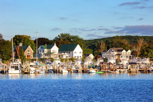
Connecticut, the southernmost state in New England, hosts over 600 miles of coastline on the Long Island Sound estuary and the Atlantic Ocean.1 The Connecticut coast is home to several large cities, including Bridgeport and New Haven, along with dozens of small towns. Around 61 percent of Connecticut’s 3.6 million residents live in coastal areas.2 The coastal region plays an important role in supporting the state’s economy with industry and tourism.3 The marine economy of Connecticut supports tens of thousands of jobs and generates billions of dollars for the state.2
Nestled along Long Island Sound and coastal rivers, Connecticut’s coastal towns offer iconic beaches and seaside architecture. For thousands of years, Indigenous People have lived in the coastal Connecticut region. For many Tribes, including the Pequot, fishing and shellfishing was an important part of diet, trade, and culture.4 Many towns steward a rich history, including Mystic, Connecticut, home to the largest maritime museum in the United States and a historic seaport. Thousands of people visit the seaport annually to learn about New England’s long, storied history with the ocean.5
Climate Impacts: Sea Level Rise Brings Increasing Tidal Flooding Challenges
Globally, warming temperatures are causing sea levels to rise. The two key ways warming temperatures affect sea level is through the addition of water from melting land ice (like glaciers and ice sheets) and the expansion of water due to warming ocean temperatures.6 Sea level along the Connecticut coast has risen about 10 to 12 inches per century, which is higher than the global average of 7 to 8 inches.7 This rise has contributed to an increase in nuisance flooding along the coast. Sometimes called high-tide, tidal, or sunny day flooding, nuisance flooding describes inundation that occurs without a storm or extreme weather.8 In Connecticut, the period from 2011 to 2020 saw nearly 43 days of nuisance flooding, which was the highest amount recorded in a 10-year period.7 By 2100, global sea level rise is projected to rise considerably, with a likely range of 1 to 4 feet, and Connecticut could experience even higher increases.7
Along the Atlantic seaboard, many places are experiencing challenges as coastal flooding occurs more often due to sea level rise. Recurrent coastal flooding can cause road closures, reduced stormwater drainage capacity, and deterioration of infrastructure not designed to withstand frequent inundation or exposure to salt water.8 Flooded roads create dangerous situations, especially when access to critical services like health care and emergency services are disrupted. Coastal flooding can affect human health by increasing the risk that drinking water and wastewater infrastructure will fail, putting people at risk of being exposed to pathogens and harmful chemicals.8
Some locations in Connecticut are at greater risk from coastal flooding. For instance, the city of New London, Connecticut, is situated at the confluence of the Thames River and Long Island Sound. The city of about 30,000 people is home to several historic sites and the United States Coast Guard Academy. Its strategic coastal location has left the city particularly vulnerable to sea level rise. In recent years, the area has been experiencing more frequent tidal flooding. By the end of the century, some projections show that tidal flooding could occur nearly every day in New London.7
Flooding also poses disproportionate risks to socially vulnerable populations. For example, in the Northeast, low-income individuals, individuals without a high school diploma, and communities of color could face disproportionate transportation delays caused by coastal flooding.9 In particular, people with low incomes are 35 percent more likely than those with higher incomes to live in areas with the highest projected traffic delays from climate-driven changes in high-tide flooding.9 As well as potentially disrupting access to critical services, transportation delays can prevent people from getting to work, which can further strain finances.
Intense Storm Surge Can Threaten Coastal Communities
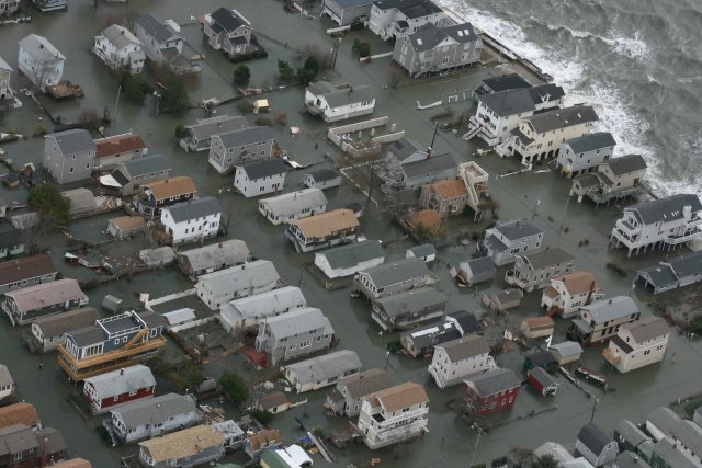
Since the 1980s, hurricanes have been intensifying more quickly, bringing heavier rainfall and increased storm surge, which can cause severe flooding and destruction.10 Flooding from storm surge can contribute to pollution issues, as it can disrupt water treatment facilities and other vulnerable utilities and structures.11 In 2012, Superstorm Sandy inundated parts of New Jersey, New York, and Connecticut, causing extensive damage and disrupting critical services. Sandy delivered major storm surges of 8 to 12 feet along different parts of the Connecticut coast.12 With more intense storms and higher sea levels, coastal communities in the Mid-Atlantic and Northeast are expected to face worsening challenges from increased storm surges and flooding.
Taking Action: Preparing for Sea Level Rise
Addressing climate change requires reducing greenhouse gas emissions while preparing for and protecting against current and future climate impacts. Communities, public officials, and individuals in every part of the United States can continue to explore and implement climate adaptation and mitigation measures. In Connecticut, researchers, planners, and stakeholders are collaborating on initiatives to prepare for and manage the impacts of sea level rise and flooding, including:
- Nature-based solutions. Marshes, dunes, and other natural features have long been important buffers that can help minimize flooding impacts. The restoration of living shorelines can help manage flooding and support coastal ecosystems.13 The Connecticut Institute for Resilience and Climate Adaptation, a partnership between the University of Connecticut and the Connecticut Department of Energy and Environmental Protection, has supported a variety of living shoreline projects focusing on marsh restoration, shoreline stabilization, and dune resiliency.13 EPA collaborates with multiple agencies to research and support initiatives that restore coastal eelgrass and marshes along the New England coast, which serve dual benefits of addressing sea level rise and sequestering carbon.14 There is a growing interest in expanding reservoirs for “blue carbon,” the carbon stored in the ocean and aquatic habitats such as marshes, mangroves, and seagrass beds.
- Resilience planning. In Connecticut, a variety of state and local partners are collaborating to assess vulnerabilities and update infrastructure to withstand more frequent flooding events.15,16 Continued mapping of the areas vulnerable to sea level rise and flooding impacts can help inform prioritization of responses and projects. Tools like the Sea Level Rise and Storm Surge Viewer from the Connecticut Institute for Resilience and Climate Adaptation help with visualizing local sea level rise.17
To learn more about climate change impacts in Connecticut and the Northeast region, see Chapter 21 of the Fifth National Climate Assessment.
Related Resources
- Climate Change: Resilience and Adaptation in New England: Blue Carbon in New England (EPA)
- EPA Climate Change Indicators: Sea Level
- EPA Climate Change Indicators: Coastal Flooding
- EPA Climate Change Indicators: Tropical Cyclone Activity
- Connecticut State Climate Summary 2022 (NOAA)
- Connecticut Department of Energy and Environmental Protection: Climate Adaptation and Resilience
- Fifth National Climate Assessment. Chapter 9: Coastal Effects
References
1 NOAA Office for Coastal Management. (n.d.). Shoreline mileage of the United States. https://coast.noaa.gov/data/docs/states/shorelines.pdf
2 NOAA Office for Coastal Management. (2024). Connecticut: Coastal management. Retrieved February 20, 2024, from https://coast.noaa.gov/states/connecticut.html
3 State of Connecticut. (n.d.). Tourism. CT.gov: Connecticut’s Official State Website. Retrieved February 20, 2024, from https://portal.ct.gov/About/Tourism
4 Hunter, R., Silliman, S. W., & Landon, D. B. (2014). Shellfish collection and community connections in eighteenth-century Native New England. American Antiquity, 79(4). http://www.jstor.org/stable/43184946
5 Mystic Seaport Museum. (n.d.). Annual reports. Retrieved February 20, 2024, from https://mysticseaport.org/about/annual-report/
6 Leung, L. R., Terando, A., Joseph, R., Tselioudis, G., Bruhwiler, L. M., Cook, B., Deser, C., Hall, A., Hamlington, B. D., Hoell, A., Hoffman, F. M., Klein, S., Naik, V., Pendergrass, A. G., Tebaldi, C., Ullrich, P. A., & Wehner, M. F. (2023). Ch. 3. Earth systems processes. In A. R. Crimmins, C. W. Avery, D. R. Easterling, K. E. Kunkel, B. C. Stewart, & T. K. Maycock (Eds.), Fifth National Climate Assessment. U.S. Global Change Research Program. https://doi.org/10.7930/NCA5.2023.CH3
7 Runkle, J., Kunkel, K. E., Champion, S. M., Easterling, D. R., Stewart, B. C., Frankson, R., Sweet, W., & Spaccio, J. (2022). Connecticut state climate summary 2022 (NOAA Technical Report NESDIS 150-CT). NOAA National Environmental Satellite, Data, and Information Service. https://statesummaries.ncics.org/chapter/ct/
8 EPA. (2023). Climate change indicators: Coastal flooding. Retrieved June 28, 2023, from https://www.epa.gov/climate-indicators/climate-change-indicators-coastal-flooding
9 EPA. (2021). Climate change and social vulnerability in the United States: A focus on six impacts (EPA 430-R-21-003). https://www.epa.gov/cira/social-vulnerability-report
10 Marvel, K., Su, W., Delgado, R., Aarons, S., Chatterjee, A., Garcia, M. E., Hausfather, Z., Hayhoe, K., Hence, D. A., Jewett, E. B., Robel, A., Singh, D., Tripati, A., & Vose, R. S. (2023). Ch. 2. Climate trends. In A. R. Crimmins, C. W. Avery, D. R. Easterling, K. E. Kunkel, B. C. Stewart, & T. K. Maycock (Eds.), Fifth National Climate Assessment. U.S. Global Change Research Program. https://doi.org/10.7930/NCA5.2023.CH2
11 EPA. (2022). Indicator reference sheet: Hurricane storm surge zone. https://www.epa.gov/system/files/documents/2022-03/storm-surge-zone-indicator-reference-sheet-20220306.pdf
12 U.S. Geological Survey. (2022). Remembering Hurricane Sandy ten years later. Retrieved December 28, 2023, from https://www.usgs.gov/centers/new-england-water-science-center/news/remembering-hurricane-sandy-ten-years-later
13 Connecticut Institute for Resilience and Climate Adaptation. (n.d.). Projects related to green infrastructure and living shorelines. University of Connecticut. Retrieved December 28, 2023, from https://circa.uconn.edu/living-shorelines/projects/
14 EPA. (2024). Blue carbon in New England. Climate Change: Resilience and Adaptation in New England (RAINE). Retrieved February 20, 2024, from https://www.epa.gov/raine/blue-carbon-new-england
15 Connecticut Institute for Resilience and Climate Adaptation. (n.d.). Projects related to critical infrastructure. University of Connecticut. Retrieved December 28, 2023, from https://circa.uconn.edu/critical-infrastructure/projects/
16 Connecticut Institute for Resilience and Climate Adaptation. (n.d.). Projects related to coastal flooding and waves. University of Connecticut. Retrieved December 28, 2023, from https://circa.uconn.edu/coastal-flooding/projects/
17 University of Connecticut. (n.d.). Connecticut sea level rise and storm surge viewer. Connecticut Institute for Resilience & Climate Adaptation (CIRCA). Retrieved December 28, 2023, from https://circa.uconn.edu/sea-level-rise-and-storm-surge-viewer/