
Climate Change Connections: Illinois (Chicago's Waterway System)
Climate change is impacting all regions and sectors of the United States. The State and Regional Climate Change Connections resource highlights climate change connections to culturally, ecologically, or economically important features of each state and territory. The content on this page provides an illustrative example. As climate change will affect each state and territory in diverse ways, this resource only describes a small portion of these risks. For more comprehensive information about regional climate impacts, please visit the Fifth National Climate Assessment and Climate Change Impacts by Sector.
On this page:

Introduction: Chicago’s Waterway Systems Are Critical for the Region
The Chicago Area Waterway System is a key part of the Illinois transportation network, connecting Lake Michigan and the Mississippi River.1 The system’s nearly 100 miles of waterways consist of constructed canals, modified natural streams, and locks.1 Annually, ships transport millions of tons of cargo along the waterways, including fuel, grains, and minerals.2

To protect Lake Michigan’s water, improve sanitation, and streamline navigation, engineers reversed the flow of the Chicago River in 1900.3 Before the reversal, raw sewage and industrial waste was discharged into the Chicago River, which at the time flowed into Lake Michigan, the source of Chicago’s drinking water. This led to public health issues including a deadly cholera outbreak.3 Recent improvements in water quality and infrastructure investments have further strengthened the Chicago community’s connection to the waterways as a central part of the city.1,4 The Chicago Riverwalk, a 1.25-mile waterfront path along the Chicago River, supports restaurants, public art exhibits, and other attractions.4
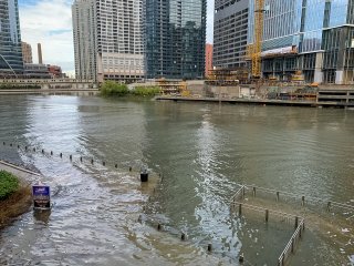
Several factors make the Chicago Area Waterway System particularly prone to flooding. As the primary drainage system for the densely populated Chicago area, these channels carry water from multiple sources, including stormwater runoff, treated wastewater outflows, and natural tributaries.5 When it rains, the combination of sewage and stormwater can exceed the sewer’s capacity, resulting in combined sewer overflows.6 Land development puts additional stress on the Chicago Area Waterway System, and urbanization in northeastern Illinois has increased the frequency and intensity of flooding through changes to natural drainage patterns.7
Climate Impacts: Increased Heavy Rainfall Contributes to More Frequent Flooding

As average temperatures at the Earth’s surface rise, more evaporation occurs, which increases overall precipitation. In some places, climate change is contributing to more heavy precipitation events, where the amount of precipitation experienced in a location substantially exceeds what is normal. Changes in the size and frequency of heavy precipitation events can affect river flooding, including in Chicago’s canal system. Illinois has experienced above-average spring and summer precipitation since the 1990s.8 In recent decades, the state has also experienced a major increase in extreme precipitation events, specifically days with two or more inches of rain.8 Extreme precipitation events can cause severe flooding with major consequences for both rural and urban areas, such as planting delays for farmers and infrastructure damage.8
Although the Tunnel and Reservoir Plan system, located underneath the streets of Chicago, can temporarily store a portion of the floodwater, multiple heavy rainfall events within a short timeframe can exceed its capacity.9 For example, in May 2020, a severe flood occurred when the tunnels and reservoirs were still holding water from a storm three days earlier.10 As a result, combined sewer overflows discharged straight into the waterway system, and the water in the channels rose over five feet.10 In extreme circumstances when the Tunnel and Reservoir Plan system is full, the waterway system operators partially reverse the flow of the canals into Lake Michigan to prevent flooding,11 which has the potential to release contaminated water into Lake Michigan.12
Extreme rainfall events have been linked to increased pollutants in the Great Lakes, which can negatively affect human health and recreation opportunities.13 As heavy rainfall episodes are projected to become more frequent, combined sewer overflows into Lake Michigan are expected to happen 50 percent to 120 percent more often by the end of the century.13 Lake Michigan is an important source of drinking water for the Chicago region. Increased extreme rainfall events and potential accompanying sewage overflows could increase the likelihood of drinking water contamination, putting human health at risk.13 Pollution can make recreation in the water unsafe, and swimming bans, which are put in place when pollutants exceed a threshold, may be expanded.
Climate change is expected to contribute to fluctuating lake levels in the Great Lakes due to periods of drought and extreme precipitation. Higher water levels in Lake Michigan could prevent the canals from draining into the lake during a storm, which could cause flooding in the city.10,11 Since 2014, the annual average water levels of Lake Michigan have been rising.14 If Lake Michigan water levels rise as climate projections predict, the Chicago area’s waterways could experience more flood control challenges. To reduce overland flooding and combined sewer overflows, the Chicago Area Waterway System has multiple safeguards.11 Although these preventative measures—like closing intakes and adjusting the release of water—are usually able to mitigate moderate flooding, more frequent or heavy flooding due to changing precipitation patterns could result in more frequent stress to the waterway system.15
Taking Action: Enhancing Flood Resilience in Waterways
Addressing climate change requires reducing greenhouse gas emissions while preparing for and protecting against current and future climate impacts. Communities, public officials, and individuals in every part of the United States can continue to explore and implement climate adaptation and mitigation measures. In Illinois, officials and planners are taking steps to prepare for increased flooding, including:
- Resilient stormwater management. Continuing to implement water management strategies that reduce the inflow of stormwater and sewage into Chicago waterways can help mitigate the impact of increasingly frequent extreme rainfall on the Chicago Area Waterway System. To help prevent combined sewer overflows, the City has installed “rainblockers,” or control valves, in storm drains along the streets of Chicago to limit the intake of stormwater into the combined sewer system.16 The Water Reclamation District of Greater Chicago has also developed a Climate Action Plan identifying both mitigation measures to reduce the carbon footprint of the system and adaptation measures to prepare for increased flooding, including leveraging more resilient infrastructure.15
- Green infrastructure. Green infrastructure, such as vegetation or permeable surfaces, can also help absorb rainfall and reduce stormwater flows to the combined sewer system.17 The rooftop garden of Chicago City Hall, for example, can absorb almost an inch of rainfall.18 Continued adaptation practices will be necessary to manage the increased risk of flooding in the Chicago Area Waterway System.
To learn more about climate change impacts in Illinois and the Midwest region, see Chapter 21 of the Fifth National Climate Assessment.
Related Resources
- Chicago Area Waterway System (EPA)
- EPA Climate Change Indicators: US and Global Precipitation
- EPA Climate Change Indicators: Heavy Precipitation
- EPA Climate Change Indicators: River Flooding
- EPA Soak Up the Rain: Resource Index
- Climate Change in Illinois (Illinois State Climatologist)
- Illinois State Climate Summary 2022 (NOAA)
References
1 EPA. (2023, July 21). Chicago Area Waterway System / Chicago River (Illinois). EPA in Illinois. Retrieved August 16, 2023, from https://www.epa.gov/il/chicago-area-waterway-system-chicago-river
2 Illinois Department of Transportation. (2021). Illinois Marine Transportation System Plan. https://idot.illinois.gov/content/dam/soi/en/web/idot/documents/transportation-system/reports/opp/marine/20210317-IDOT-IMTS%20Plan-Web%20(MAR%202021).pdf
3 National Park Service. (1998). Chicago’s living rivers. Rivers, Trails, and Conservation Assistance Program, Milwaukee, Wisconsin. https://www.nrs.fs.usda.gov/pubs/misc/chicagoriver/pdf/pamphlet.pdf
4 City of Chicago Department of Assets, Information and Services. (n.d.). Site history. Chicago Riverwalk. Retrieved August 16, 2023, from https://www.chicago.gov/content/city/en/sites/chicagoriverwalk/home/site-history.html
5 Duncker, J. J., & Johnson, K. K. (2015). Hydrology of and current monitoring issues for the Chicago Area Waterway System, Northeastern Illinois (Scientific Investigations Report No. 2015–5115). U.S. Geological Survey. https://pubs.usgs.gov/sir/2015/5115/sir20155115.pdf
6 EPA Office of Water. (2023). Combined sewer overflow basics. National Pollutant Discharge Elimination System. Retrieved August 20, 2023, from https://www.epa.gov/npdes/combined-sewer-overflow-basics
7 Hejazi, M. I., & Markus, M. (2009). Impacts of urbanization and climate variability on floods in Northeastern Illinois. Journal of Hydrologic Engineering, 14(6), 606–616. https://doi.org/10.1061/(ASCE)HE.1943-5584.0000020
8 Frankson, R., Kunkel, K. E., Champion, S. M., Stewart, B. C., Easterling, D. R., Hall, B., Angel, J. R., & Timlin, M. S. (2022). Illinois state climate summary 2022 (NOAA Technical Report NESDIS 150-IL). NOAA National Environmental Satellite, Data, and Information Service. https://statesummaries.ncics.org/chapter/il/
9 Metropolitan Water Reclamation District of Greater Chicago. Tunnel and Reservoir Plan (TARP). (n.d.). Retrieved August 18, 2023, from https://mwrd.org/tunnel-and-reservoir-plan-tarp
10 Egan, D. (2021). A battle between a great city and a Great Lake. The New York Times. https://www.nytimes.com/interactive/2021/07/07/climate/chicago-river-lake-michigan.html
11 Metropolitan Water Reclamation District of Greater Chicago. Chicago Area Waterway System operations. (2023). Retrieved December 1, 2023, from https://mwrd.org/what-we-do/reducing-flooding/chicago-area-waterway-system-caws/chicago-area-waterway-system-operations
12 EPA. (2007). Report to Congress: Combined sewer overflows to the Lake Michigan Basin. https://www.epa.gov/sites/default/files/2015-10/documents/cso_reporttocongress_lakemichigan.pdf
13 Patz, J. A., Vavrus, S. J., Uejio, C. K., & McLellan, S. L. (2008). Climate change and waterborne disease risk in the Great Lakes Region of the U.S. American Journal of Preventive Medicine, 35(5), 451–458. https://doi.org/10.1016/j.amepre.2008.08.026
14 EPA. (2021). Climate change indicators: Great Lakes water levels and temperatures. Retrieved August 21, 2023, from https://www.epa.gov/climate-indicators/great-lakes
15 Metropolitan Water Reclamation District of Greater Chicago. (2023). Climate Action Plan. Retrieved January 15, 2025 from https://mwrd.org/what-we-do/climate-action-plan
16 City of Chicago. Blocking rainwater and preventing sewer backup. (n.d.). Retrieved August 22, 2023, from https://www.chicago.gov/content/city/en/depts/water/provdrs/engineer/svcs/blocking_rainwaterandpreventingsewerbackup.html
17 EPA OW. (2024, September 30). What is green infrastructure? [Overviews and Factsheets]. Green Infrastructure. Retrieved August 22, 2023, from https://www.epa.gov/green-infrastructure/what-green-infrastructure
18 City of Chicago. City Hall’s rooftop garden. (2014, April). City of Chicago. Retrieved August 22, 2023, from https://www.chicago.gov/content/city/en/depts/dgs/supp_info/city_hall_green_roof.html