
Climate Change Connections: Missouri (Missouri River)
Climate change is impacting all regions and sectors of the United States. The State and Regional Climate Change Connections resource highlights climate change connections to culturally, ecologically, or economically important features of each state and territory. The content on this page provides an illustrative example. As climate change will affect each state and territory in diverse ways, this resource only describes a small portion of these risks. For more comprehensive information about regional climate impacts, please visit the Fifth National Climate Assessment and Climate Change Impacts by Sector.
On this page:

Introduction: The United States’ Longest River Supports Ecosystems and Economies
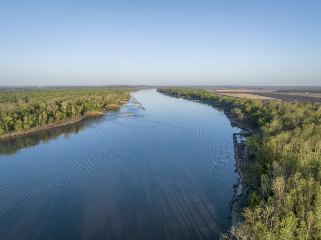
Beginning in the mountains of Montana, the Missouri River flows more than 2,500 miles across the Great Plains before converging with the Mississippi River in St. Louis, Missouri.1 The Missouri River, also called the “Big Muddy,” collects water drained from the Missouri River Basin, which encompasses over 525,000 square miles across 10 states.1 The river is fed by tributaries, rainfall, and snowmelt from both mountains and prairies.
Though much of the Missouri River exists outside the state of Missouri, the upstream impacts are important for the reach of the river that meanders through the state. The river cuts through the center of Missouri and is the lifeblood of the state’s agriculture, hydropower, and recreation. Three of the state’s major cities, Kansas City, St. Louis, and Columbia, are situated on the banks of the “Big Muddy.”
Climate Impacts: Climate Change Means “Boom or Bust” in the Missouri River Basin, With More Extreme Rain and Drought Events Expected
Climate change can affect the intensity and frequency of precipitation, which can worsen existing water challenges. As average temperatures at the Earth’s surface rise, more evaporation and transpiration occur and add more moisture to the air, which in turn increases overall precipitation. In recent decades, more rainfall has been occurring as intense single-day rainfall events.2 Heavy precipitation is when the amount of rain or snow substantially exceeds what is normal in a location, which depends on a variety of factors. The state of Missouri has seen an increase in extreme rainfall events and the frequency and intensity of these events are expected to increase.3
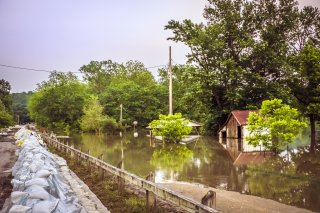
The intensity of precipitation matters because infrastructure, such as drains and dams, is built based on a region’s typical weather conditions. Extreme heavy rainfall in a short period can overwhelm a city’s stormwater system or overtake the banks of a river, harming neighboring communities. Flooding of major midwestern rivers like the Mississippi, Missouri, and Ohio can inundate crops, damage infrastructure, and contaminate drinking water.4 Floods can also cause mold growth in buildings that threatens occupants’ health.
The Missouri River Basin recently experienced extreme precipitation events that caused damaging and expensive floods. For example, after record snowfall in 2011, a massive Missouri River flood inundated numerous buildings, roads, and crops along the river and, combined with Mississippi River flooding, caused an estimated $5.7 billion in damage.5,6 The Missouri River Basin also experienced major flooding in 2019, with parts of the river and its tributaries staying above flood stage for much of the year.7 Multiple factors, including exceptionally heavy precipitation in the winter of 2018–2019 and a cold air mass in January that caused deep ground freezing, created conditions that contributed to severe flooding. In March 2019, a rapidly forming severe storm called a “bomb cyclone” and subsequent periods of intense rainfall throughout the summer led to flooding that inundated farms and destroyed infrastructure, causing evacuations.7 Climate change is expected to bring increased precipitation with more extreme rainfall events, which could worsen flooding issues across the Great Plains and Midwest regions.8
The Missouri River Basin is also projected to face continued challenges from drought.9 Droughts are prolonged periods of unusually dry weather that have wide-ranging effects. Droughts limit how much water is available for agriculture, which is an important economic driver in the Midwest. Droughts can also lower water levels in commercial waterways, interrupting transportation and shipping.4 Droughts are complex events that often result from a confluence of factors—including atmospheric conditions (e.g., temperature, humidity, ocean surface conditions), circulation patterns (e.g., the jet stream), and landscape conditions (e.g., vegetation coverage, soil moisture)—all of which disrupt the water cycle and the amount of precipitation an area normally receives. Additional warming caused by climate change influences all these contributing factors, the relationships among them, and the swings between wet and dry conditions. The “whiplash effect” of back-to-back drought and flooding also has negative impacts. These rapid changes between extreme conditions harm water quality, as the transition can contribute to higher levels of nitrogen in the water from agricultural fields.10
Taking Action: Planning for Changing Conditions
Addressing climate change requires reducing greenhouse gas emissions while preparing for and protecting against current and future climate impacts. Communities, public officials, and individuals in every part of the United States can continue to explore and implement climate adaptation and mitigation measures. In Missouri, state and regional partners and planners are taking steps to prepare for the drought and flooding expected to further threaten the Missouri River Basin, including:
- Open space preservation and restoration of floodplains. With expected increases in heavy precipitation events that result in flooding, many communities are investing in strategies to mitigate flooding impacts. Floodplain restoration projects can help protect buffer zones in floodplains to better absorb and filter rainwater and flooding.4 Conservation easements, which allow property owners to conserve natural areas,11 can minimize development and preserve open space.
- Resilience planning. Safeguarding the people, homes, and infrastructure along the Missouri River from flooding requires careful study and anticipation of future conditions. Officials at the local, state, and national level are working cooperatively to build resilience and establish good river management practices. In 2019, Missouri partnered with Kansas, Iowa, Nebraska, and the U.S. Army Corps of Engineers to improve flood protection in the watershed.12 Research and field work are ongoing.
To learn more about climate change impacts in Missouri and the Midwest region, see Chapter 24 of the Fifth National Climate Assessment.
Related Resources
- EPA Climate Change Indicators: River Flooding
- EPA Climate Change Indicators: Drought
- Missouri State Climate Summary 2022 (NOAA)
- Missouri Climate Center (University of Missouri)
References
1 U.S. Bureau of Reclamation. (2021). Missouri River Basin SECURE Water Act Section 9503(c) [Report to Congress]. https://www.usbr.gov/climate/secure/docs/2021secure/basinreports/MissouriBasin.pdf
2 Marvel, K., Su, W., Delgado, R., Aarons, S., Chatterjee, A., Garcia, M. E., Hausfather, Z., Hayhoe, K., Hence, D. A., Jewett, E. B., Robel, A., Singh, D., Tripati, A., & Vose, R. S. (2023). Ch. 2. Climate trends. In A. R. Crimmins, C. W. Avery, D. R. Easterling, K. E. Kunkel, B. C. Stewart, & T. K. Maycock (Eds.), Fifth National Climate Assessment. U.S. Global Change Research Program. https://doi.org/10.7930/NCA5.2023.CH2
3 Frankson, R., Kunkel, K. E., Champion, S. M., & Stewart, B. C. (2022). Missouri state climate summary 2022 (NOAA Technical Report NESDIS 150-MO). NOAA National Environmental Satellite, Data, and Information Service. https://statesummaries.ncics.org/chapter/mo/
4 Wilson, A. B., Baker, J. M., Ainsworth, E. A., Andresen, J., Austin, J. A., Dukes, J. S., Gibbons, E., Hoppe, B. O., LeDee, O. E., Noel, J., Roop, H. A., Smith, S. A., Todey, D. P., Wolf, R., & Wood, J. D. (2023). Ch. 24. Midwest. In A. R. Crimmins, C. W. Avery, D. R. Easterling, K. E. Kunkel, B. C. Stewart, & T. K. Maycock (Eds.), Fifth National Climate Assessment. U.S. Global Change Research Program. https://doi.org/10.7930/NCA5.2023.CH24
5 Hoerling, M., Eischeid, J., & Webb, R. (2013). Climate assessment report: Understanding and explaining climate extremes in the Missouri River Basin associated with the 2011 flooding. NOAA Office of Oceanic and Atmospheric Research, Earth System Research Laboratory Physical Sciences Division, and Cooperative Institute for Research in Environmental Sciences, University of Colorado, Boulder. https://psl.noaa.gov/csi/factsheets/pdf/noaa-mrb-climate-assessment-report.pdf
6 Lall, U., Johnson, T., Colohan, P., Aghakouchak, A., Brown, C., McCabe, G., Pulwarty, R., & Sankarasubramanian, A. (2018). Ch. 3. Water. In D. R. Reidmiller, C. W. Avery, D. R. Easterling, K. E. Kunkel, K. L. M. Lewis, T. K. Maycock, & B. C. Stewart (Eds.), Impacts, risks, and adaptation in the United States: Fourth National Climate Assessment, volume II. U.S. Global Change Research Program. https://doi.org/10.7930/NCA4.2018.CH3
7 NOAA, U.S. Department of Agriculture, & High Plains Regional Climate Center. (2020). Extreme wetness of 2019 - Missouri River Basin. https://hprcc.unl.edu/pdf/2019Extremes.pdf
8 Payton, E. A., Pinson, A. O., Asefa, T., Condon, L. E., Dupigny-Giroux, L.-A. L., Harding, B. L., Kiang, J., Lee, D. H., McAfee, S. A., Pflug, J., Rangwala, I., Tanana, H. J., & Wright, D. B. (2023). Chapter 4: Water. In A. R. Crimmins, C. W. Avery, D. R. Easterling, K. E. Kunkel, B. C. Stewart, & T. K. Maycock (Eds.), Fifth national climate assessment. U.S. Global Change Research Program. https://nca2023.globalchange.gov/chapter/4/
9 U.S. Drought Monitor. (n.d.). Missouri. Retrieved December 29, 2023, from https://droughtmonitor.unl.edu/CurrentMap/StateDroughtMonitor.aspx?MO
10 Loecke, T. D., Burgin, A. J., Riveros-Iregui, D. A., Ward, A. S., Thomas, S. A., Davis, C. A., & Clair, M. A. St. (2017). Weather whiplash in agricultural regions drives deterioration of water quality. Biogeochemistry, 133(1), 7–15. https://doi.org/10.1007/s10533-017-0315-z
11 EPA. (2021). Stormwater best management practice, conservation easements. https://www.epa.gov/system/files/documents/2021-11/bmp-conservation-easements.pdf
12 Missouri Department of Natural Resources. (2024). Lower Missouri River flood resiliency studies. Retrieved August 13, 2024, from https://dnr.mo.gov/water/what-were-doing/initiatives/lower-missouri-river-flood-resiliency