Temperate Plains Ecoregion - National Rivers and Streams Assessment 2013-14
Setting
The Temperate Plains ecoregion includes Iowa; the eastern Dakotas; western Minnesota; portions of Missouri, Kansas, and Nebraska; and the flatlands of western Ohio, central Indiana, Illinois, and southeastern Wisconsin. This ecoregion covers about 342,200 square miles, or 11%, of the conterminous U.S., with approximately 7,900 square miles under federal ownership. Many of the rivers in this ecoregion drain into the upper Mississippi River, Ohio River, and Great Lakes watersheds.
Much of this ecoregion is now primarily agricultural land, including land used for field crop production (e.g., corn, wheat, and alfalfa) and hog and cattle production. Crops and grazing have reduced natural riparian vegetative cover, increased sediment yield, and introduced pesticides and herbicides. Rivers have many species of fish, including minnows, darters, killifishes, catfishes, suckers, sunfishes, and black bass.
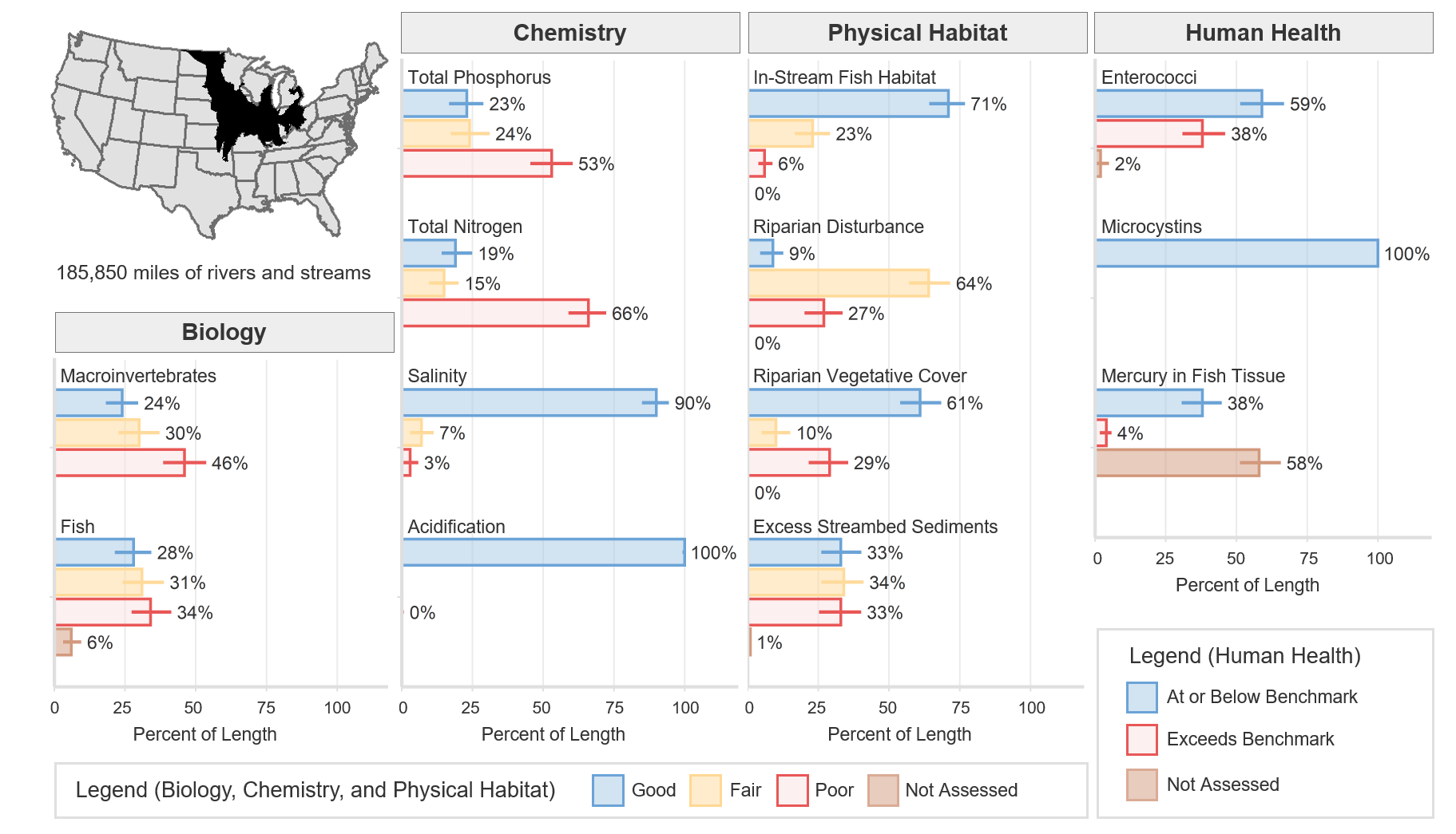
Rivers and streams in the tallgrass prairie start from prairie potholes and springs, and they may be ephemeral (flowing for a short time only after snowmelt or rainfall). Rivers carry large volumes of fine sediments and tend to be turbid, wide, and shallow. The total river and stream length represented in NRSA 2013–14 for the Temperate Plains ecoregion is 185,850 miles.
The terrain of this ecoregion consists of smooth plains and many small lakes and wetlands. The climate is temperate, with cold winters, hot and humid summers, and mean temperatures ranging from 36°F to 55°F. Annual precipitation ranges from 16 to 43 inches.
Biological Indicators
The macroinvertebrate MMI showed that 24% of river and stream length in the Temperate Plains ecoregion was of good quality (based on the least-disturbed reference distribution). The fish MMI showed that 28% of river and stream length was of good quality. Six percent of river and stream length was not assessed or, for various reasons, had insufficient data to calculate the fish MMI.
Chemical and Physical Habitat Indicators
The percentage of miles rated good for chemical and physical habitat indicators varied widely within the Temperate Plains ecoregion. Phosphorus and nitrogen tended to have a lower percentage of river and stream miles with good quality, 23% and 19% respectively, compared to physical habitat measures such as in-stream fish habitat, riparian vegetation cover, and excess streambed sediments, which had 71%, 61%, and 33%, respectively.
Human Health Indicators
Human health indicators measured within the Temperate Plains ecoregion showed that most of the river and stream miles were below levels of concern. Enterococci were at or below the national benchmark for 59% of river and stream length. Microcystins were at or below the national benchmark for 100% of river and stream length. Mercury in fish tissue plugs was at or below the national benchmark for 38% of river and stream length, with 58% unassessed for a variety of reasons, including the absence of fish, the lack of habitat to support fish that met the minimum size requirement, inability to obtain permits, inclement weather, and site access denial.