Western Mountains Ecoregion - National Rivers and Streams Assessment 2013-14
Setting
The Western Mountains ecoregion includes the Cascade, Sierra Nevada, and Pacific Coast ranges in the coastal states; the Gila Mountains in the southwestern states; and the Bitterroot and Rocky mountain ranges in the northern and central mountain states. The headwaters and upper reaches of the Columbia, Sacramento, Missouri, and Colorado river systems all occur in this ecoregion. This ecoregion covers about 397,832 square miles, with about 297,900 square miles, or 75% of the land, classified as federal land.
The terrain of the Western Mountains ecoregion is characterized by extensive mountains and plateaus separated by wide valleys and lowlands. Coastal mountains are transected by many fjords and glacial valleys, are bordered by coastal plains, and include important estuaries along the margins of the ocean. Soils are mainly nutrient-poor forest soils. Rivers drain dense forested catchments and contain much woody debris that provides habitat diversity and stability. Rivers reaching the Pacific Ocean historically had large runs of salmon and trout; however, many of these populations have been reduced by the effects of dams, flow regulation, overfishing, and invasive species. Smaller rivers generally start as steep mountain streams with staircase-like channels, steps, and plunge pools, with riffles and pools appearing as the slope decreases. Upper river reaches experience debris flows and landslides when shallow soils become saturated by rainfall or snowmelt. The total river and stream length represented in NRSA 2013–14 for the Western Mountains ecoregion is 186,538 miles.
The climate is sub-arid to arid and mild in southern lower valleys; it is humid and cold at higher elevations. The wettest climates of North America occur in the marine coastal rainforests of this ecoregion. Mean annual temperatures range from 32°F to 55°F, and annual precipitation ranges from 16 to 240 inches.
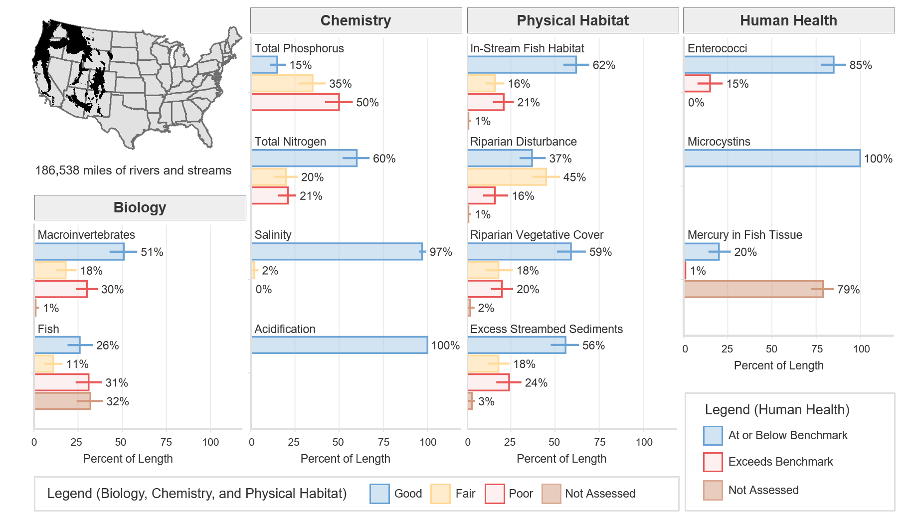
Biological Indicators
The macroinvertebrate MMI showed that 51% of river and stream length in the Western Mountains ecoregion was of good quality (based on the least-disturbed reference distribution). The fish MMI showed that 26% of river and stream length was of good quality. Thirty-two percent of river and stream length was not assessed or, for various reasons, had insufficient data to calculate the fish MMI.
Chemical and Physical Habitat Indicators
The percentage of miles rated good for chemical and physical habitat indicators varied widely within the Western Mountains ecoregion. Phosphorus had a low percentage (15%) of river and stream miles in good condition, whereas nitrogen had the highest percentage (60%) of river and stream miles with good quality, as compared to other ecoregions. Physical habitat measures such as in-stream fish habitat, riparian vegetation cover, and excess streambed sediments showed high percentages of rivers and stream miles rated good, 62%, 59%, and 56%, respectively.
Human Health Indicators
Human health indicators measured within the Western Mountains ecoregion showed that most of the river and stream miles were below levels of concern. Enterococci were at or below the national benchmark for 85% of river and stream length. Microcystins were at or below the national benchmark for 100% of river and stream length. Mercury in fish tissue plugs was at or below the national benchmark for 20% of river and stream length, with 79% unassessed for a variety of reasons, including the absence of fish, the lack of habitat to support fish that met the minimum size requirement, inability to obtain permits, inclement weather, and site access denial.