Xeric Ecoregion - National Rivers and Streams Assessment 2013-14
Setting
The Xeric ecoregion covers the largest area of all NRSA aggregate ecoregions and includes the most total land under federal ownership. It covers portions of 11 western states and all of Nevada, for a total of approximately 636,583 square miles, or 21% of the conterminous U.S. Approximately 453,000 square miles, or 71% of the land, are classified as federal lands, including Grand Canyon National Park, Big Bend National Park, and Hanford Nuclear Reservation.
The terrain of the Xeric ecoregion is composed of a mix of physiographic features, including plains with hills and low mountains, high-relief tablelands, piedmont, high mountains, and intermountain basins and valleys. The ecoregion includes the flat to rolling topography of the Columbia/Snake River Plateau; the Great Basin; Death Valley; and the canyons, cliffs, buttes, and mesas of the Colorado Plateau. Its relatively limited surface water supply contributes to the Upper and Lower Colorado, Great Basin, California, Rio Grande, and Pacific Northwest regional watersheds. Large rivers flow all year, are supplied by snowmelt, and peak in early summer. Small rivers are mostly ephemeral. Rivers are often subject to rapid change due to flash floods and debris flows. In southern areas of the ecoregion, internal drainages often end in saline lakes or desert basins without reaching the ocean (e.g., Utah’s Great Salt Lake).
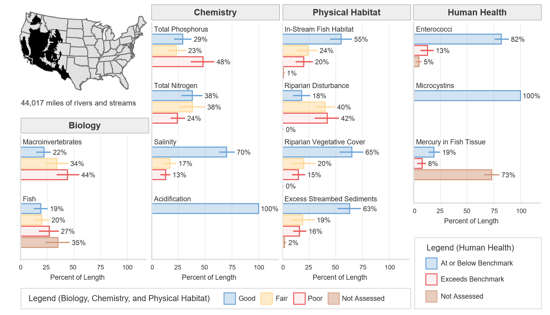
Rivers in this ecoregion create a riparian habitat oasis for plants and animals. Many fish are endemic and have evolved to cope with warm, turbid waters. The total river and stream length represented in NRSA 2013–14 for the Xeric ecoregion is 44,017 miles.
The climate in this ecoregion varies widely from warm and dry to temperate, with mean annual temperatures ranging from 32°F to 75°F and annual precipitation ranging from 2 to 40 inches.
Biological Indicators
The macroinvertebrate MMI showed that 22% of river and stream length in the Xeric ecoregion was of good quality (based on the least-disturbed reference distribution). The fish MMI showed that 19% of river and stream length was of good quality. Thirty-five percent of river and stream length was not assessed or, for various reasons, had insufficient data to calculate the fish MMI.
Chemical and Physical Habitat Indicators
The percentage of miles rated good for chemical and physical habitat indicators varied widely within the Xeric ecoregion. Phosphorus and nitrogen tended to have a lower percentage of river and stream miles with good quality, 29% and 38% respectively; however, the percentage of river and stream miles with poor quality for nitrogen was half as much as that for phosphorus, 24% and 48% respectively. Physical habitat measures such as in-stream fish habitat, riparian vegetation cover, and excess streambed sediments showed high percentages of rivers and stream miles rated good, 55%, 65%, and 63%, respectively.
Human Health Indicators
Human health indicators measured within the Xeric ecoregion showed that most of the river and stream miles were below levels of concern. Enterococci were at or below the national benchmark for 82% of river and stream length. Microcystins were at or below the national benchmark for 100% of river and stream length. Mercury in fish tissue plugs was at or below the national benchmark for 19% of river and stream length, with 73% unassessed for a variety of reasons, including the absence of fish, the lack of habitat to support fish that met the minimum size requirement, inability to obtain permits, inclement weather, and site access denial.